
History of geological study on Anglesey
the history of geological study on Anglesey goes back to John Henslow (1796-1861) even though geologists first think of Edward Greenly when they hear of Anglesey. Henslow was educated at St John’s College, Cambridge where he graduated in 1818, the year in which Adam Sedgwick became Woodwardian Professor of Geology. He developed a passion for geology and accompanied Sedgwick on fieldwork. He arrived on Anglesey to investigate aspects of the island’s geology, recognising the belts of “chloritic schists” and other exotic rocks, and published his observations in the first volume of the Transactions of the Cambridge Philosophical Society in 1822.
Anglesey has long been the focus of geological interest; it is speculated – although not documented – that Charles Darwin, prior to embarking on the HMS Beagle, visited the Island on his June 1842 tour of North Wales with Adam Sedgwick since he had relatives living on the island and there is a day’s gap in his diary after he arrived in Bangor. Michael Roberts has just published a detailed examination of Darwin’s trip across North Wales citing evidence from Darwin’s account of his voyage on the Beagle where he draws on his knowledge of Anglesey rocks to show he must have visited the island and studied the geology.
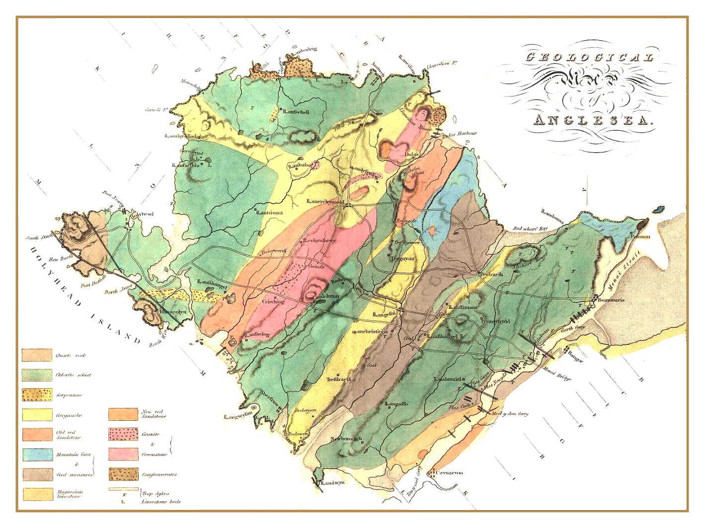
Anglesey is possibly one of the most geologically mapped areas in Britain; Darwin’s tutor at Cambridge, John Henslow, published the first map and account of the geology of Anglesey in 1822.
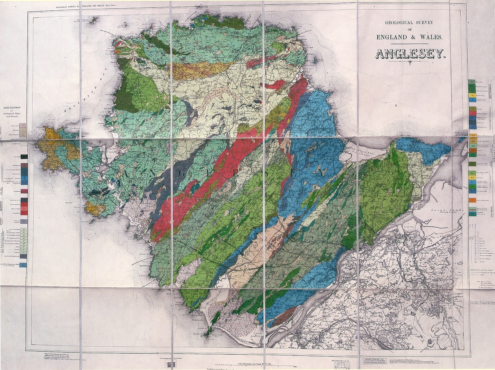
The island was again mapped by Ramsay in the 1840s and his map was reused by others including this by Woodward in 1904

It was nearly a century later before Edward Greenly retired to Anglesey and began his meticulously detailed account of the Geology of Anglesey. now available online thanks to the The GeoGuide website which is part of a wider project, led by the Scottish Geology Trust,
Greenly’s ‘bedded’ sequence of Precambrian rocks was said to be stratigraphically continuous, beginning with the Gwna Group, passing up through the New Harbour Group with the South Stack Group being the youngest. The sequence was then recumbently folded and metamorphosed, leaving parts upside down and with an increase in metamorphic grade towards the south-east where the Blueschists are to be found. He regarded the Gneisses as an ancient basement and the intrusion of the Coedana Granite as a post-metamorphic event, finishing the development of his Precambrian ‘Mona Complex’.


Subsequently many geologists have examined his supposed PreCambrian sequence but there are two key problems to any worker looking at these older rocks on the island:
- younger rocks (Ordovician to Permo-Triassic) and glacial sediments are present in many areas, obscuring the picture.
- where exposure is better, the rock units are separated by hotly debated breaks which, to some are stratigraphic, while to others they are tectonic.
Imagine a jigsaw puzzle, almost complete around the edges (the coast), but with big holes in the middle (inland) – and those few completed bits in the middle all radically different from one another. That’s Anglesey’s geology in a nutshell, and that’s why it draws so many research teams to whom the unsolved problems are among the greatest geological challenges left in the UK.
Robert Shackleton substantially revised the geology in 1965. He considered the bedded strata to be the right way up, thus inverting Greenly’s sequence, with the South Stack Group at the bottom and the Gwna Group the youngest. He considered the Coedana Gneisses to be their high-grade metamorphic equivalent, the culmination of which was melting, producing the Coedana Granite.
During the 1970s, two key papers were published regarding the ultrabasic rocks within the New Harbour Group. Alec Maltman argued the case for their emplacement purely by intrusive processes. Richard Thorpe argued that they had been tectonically emplaced as part of an ophiolite sequence.
In 1979 a proliferation of papers sparked some of the most robust debate ever witnessed in UK geological research. Much of this was centred around a paper published by Anthony Barber and Michael Max (Journal of the Geological Society) which restored Greenly’s stratigraphy but with an important difference – they considered the three bedded units to be separated by tectonic breaks. A relatively undeformed South Stack Group was overthrust by an already highly deformed New Harbour Group. The Gwna Group on the other hand is relatively undeformed, and might have been unconformably deposited onto the New Harbour Group. Shackleton’s view of the Coedana Gneisses representing high-grade metamorphism of the bedded units was rejected and once again the gneisses were considered to be an ancient basement. The Blueschists in the south were regarded as representing a tectonically complex zone of imbrication from a relatively deep level in a subduction zone.
The late Dennis Wood, a geologist with a lifelong association with the island’s rocks [GeoMôn installed a memorial to him at Rhoscolyn], was strident in his view that the South Stack and New Harbour groups were conformable and it was their lithological differences that had led to different textures produced by the same deformation. He considered the bedded units to pass with increasing metamorphic grade into the Gneisses and into the Coedana Granite.
Thorpe and Beckinsale presented Rb-Sr whole-rock isotopic analyses for the Gneisses and the Coedana Granite to show a late Precambrian age (around 600Ma) for metamorphism and melting, endorsing Shackleton’s and Wood’s view of their origin.
Margaret Wood observed fossils in the limestone clasts of the Gwna Mélange, describing stromatolites (algal mats) from the north coast in 1973 whilst Muir and colleagues described microfossils from the same clasts in 1979. “In describing the stromatolitic (blue-green algae) limestones, Margaret gave a date of 600 to 900 million years old and in 2011 Jana Horak and J.A. Evans dated the stromatolite limestones from the Cemaes area as 800 to 860 million years old, proving they were all from the Precambrian Era. They are the oldest known fossils in Wales. These rocks are particularly interesting as they are sedimentary, as opposed to those further South in Anglesey, that all display various stages of metamorphism. Stromatolites (cyanobacteria) are the oldest known fossils in the World and were found in rocks only 1000 million years after our planet existed and, they still occur in present day rocks. They are probably the most important rocks to us as they contained the first bacteria, cyanobacteria, that photosynthesised and produced oxygen.They are our most ancient ancestors! At the end of the Precambrian Era, the cyanobacteria, eventually, had produced enough oxygen to allow other lifeforms to develop. That time was around 540 million years ago and is known as the Cambrian ‘explosion’. This Period heralded in a new Era where life was able to evolve, The Palaeozoic Era.

The last decades of the 20th century saw much new work, including work on the Coedana Complex and the Blueschist Belt by Jana Horak and co-workers. By 2000, it was widely considered that Anglesey was made up of three individual terranes, the Monian Supergroup (the bedded units), the Coedana Complex (gneisses and granite) and the Blueschist Belt, collectively being referred to as the Monian Composite Terrane. These terranes were thought to have widely differing metamorphic histories, and had docked together before becoming accreted to the rest of England and Wales (or Avalonia, to use its geological name) at the major shear-zone that bounds the Blueschist Belt along the Menai Strait.
Progress was also made regarding the age of some of the rocks. Ar-Ar radiometric dating of the Blueschist Belt gave two ages – the oldest, 580-590 million years ago being considered to mark sea-floor metamorphism and the youngest, 550-560 million years ago, representing the metamorphism in the subduction zone. Thus, the Blueschists were definitely late Precambrian.
In 2004 there came the confirmation that at least one of the bedded units was, however, considerably younger. U-Pb data obtained from detrital zircons in the South Stack Group, indicated a maximum age for these rocks of 500 million years, or very solidly Cambrian in age; therefore the Coedana Gneisses cannot be highly metamorphosed equivalents of the bedded units as they’re over 100 million years older.
In recent years a team of Japanese scientists, working with Brian Windley of Leicester University, has been undertaking a variety of studies. Japan lies on a subduction zone, and this team has spent many years studying such features in their local area. Some valuable new data and interesting interpretations are emerging: perhaps a key conclusion is that, for all its tectonic dismemberment, Anglesey is in fact a classic example of an ancient accretionary orogenic belt, with an exhumed blueschist, a late Precambrian mélange with many oceanic components, an ophiolite sequence and a passive margin sedimentary basin sequence of Cambrian age.
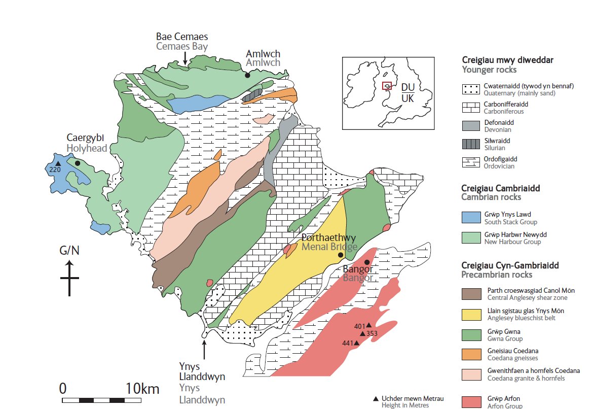 GeoMôn Geology of Anglesey map 2020
So, we go into the future with new interpretations going into publication, which again will attract great interest and inspire new generations of research geologists to come over to Anglesey and continue the study of its extraordinarily complex, controversial, inspiring and sometimes frustrating rocks.
References
BGS Maps of Anglesey
Campbell, S. Wood, M & Windley, B. 2014. Footsteps through time : the rocks and landscapes of Anglesey explained. (availableto buy from our online shop)
and most famously in tremendous detail by Edward Greenly who had retired from the Geological Survey after working in Scotland and spent the rest of his life touring Anglesey examining every bit of rock he could find. His work was published in 1919 as both a map and an extensive memoir. You can download a PDF copy of Greenly’s Geology of Anglesey
During his work he was assisted by his long suffering wife Annie who learnt geology from her husband as they carried out the survey. Prof Cynthia Burek has written an article (Burek, 2007) on both Annie Greenly and Catherine Raisin who did much to advance the understanding of the metamorphic rocks of Anglesey. See a poster version : A tale of two female geologists on Anglesey
Research has continued up to the present-day, GeoMôn staff have accompanied and assisted various groups carrying out research and mapping; most recently this was with the Universities of Leicester and Tokyo. The occurrence of fossils in the limestone blocks of the Gwna Mélange came to light when Dr Margaret Wood described stromatolites (algal mats) from the north coast (Wood and Nicholls 1973); these have since been dated to around 860Ma and are the oldest fossils in England or Wales. Dr Wood was invited to submit the Melange as one of the 100 most significant exposures by Japanese scientists (Wood, 2012) who ranked it as number 7 in the world
Given Anglesey’s interesting and well-exposed geology, coupled with its popularity as a holiday destination, there are surprisingly few modern field-guides covering the island’s geology (Treagus, 2008; Conway 2010); however, the publication by the Geologists’ Association (Bates and Davies 1984) has gone through at least four reprints indicating that the demand for a technical publication is remarkably strong.
References
Burek, C.V. 2007. The role of women in geological higher education Bedford College, London (Catherine Raisin), In Burek & Higgs (eds) The role of women in the history of geology. Geol. Soc. London Spec. Pub. 281, 9-38
Conway, J S, 2010 Rocks and landscapes of the Anglesey Coastal Footpath / Creigiau a thirweddau Llwybr Arfordirol Ynys Môn, GeoMon (bilingual)
Greenly E, 1919 Geology of Anglesey, Memoirs of the Geological Survey of Great Britain (2 vols), Geological Survey of Great Britain, HMSO, London
Henslow J, 1822 Geological Description of Anglesea, J Smith, Cambridge
Treagus, J, 2008 Anglesey Geology – a field guide. Seabury Salmon and Associates
Wood, M, 2007 Application dossier for nomination to the European Geopark Network (unpublished), GeoMôn Anglesey Geopark
Wood, M 2012 The Historical Development of the term melange and its relevance to the Precambrian geology of Anglesey and the Lleyn Peninsula in Wales, UK. The 100’s significant Exposures of the World, Japanese Journal of Geography 7, 168-180
Wood, M and Nicholls, G D, 1973 Precambrian stromatolites from Northern Anglesey. Nature 241, 65
Wood, M, Campbell, S, Roberts, R, Brenchley P, Conway, J S, Crossley, R, Davies, J, Fitches, B, Mason, J, Matthews, B, Treagus, J, and Williams, T, 2007a Developing a methodology for selecting Regionally Important Geodiversity Sties (RIGS) in Wales and a RIGS survey of Anglesey and Gwynedd. Volume 1: Methodology. Report to Welsh Assembly Government, Cardiff
Wood, M, Campbell, S, Roberts, R, Brenchley P, Conway, J S, Crossley, R, Davies, J, Fitches, B, Mason, J, Matthews, B, Treagus, J, and Williams, T, 2007b Developing a methodology for selecting Regionally Important Geodiversity Sites (RIGS) in Wales and a RIGS survey of Anglesey and Gwynedd. Volume 2: Site Survey. Report to Welsh Assembly Government, Cardiff