

Geological time periods
The Earth is some 4.5 billion years old – but how do we know that ? Geological time seems to stretch out forever into the unimaginally distant past. How do we measure it? How do we divide it up into manageable chunks (Geological time periods)? Once we’ve sorted out the UK, how do we relate to different parts of the world? Lots to think about. And it didn’t all get sorted out at once.
Thinking about how the earth works evolved slowly as different people observed different aspect of the natural world. In the early days there were no scientists, no geologists, no “experts” – just interested people either observing the world around them, or “engineers / surveyors” trying to build canals, roads or railways and encountering problems!
One of the earliest was William Smith, a canal surveyor in Somerset and the Bath area, who encountered problems cutting the canal, and noticed fairly regular alternation of rock types. Smith surveyed routes for the canal in 1794, canal excavations were an ideal way to see vertical sections as the precise level of the canal was known. By 1795 he had deciphered the local order of strata from the Great Oolite down to the Triassic “Red Ground”, recognising several repetitious clay formations and separating the Upper and Lower Oolite. By August 1797, Smith had made his first attempt at a more general order of strata starting with Number 1 “Chalk Strata” and descending to Number 28 “Limestone” below the Coal Measures.
He went on not only to draw maps but to mark out the way the rocks were dipping (identifying the maximum angle of dip above or below the horizontal). He extended his observations across England and Wales creating the first extensive geological map, which is amazingly accurate at the broad scale. The eventual outcome of Smith’s research was ‘A Geological Map of England and Wales and Part of Scotland’, first published in 1815. On a scale of 5 miles per inch, the map measured 6 feet by 8 feet 6 inches. It was not the world’s first geologic map, but it was the first to map such a large area in such detail. Hiswork predated the establishment of names for geological time periods and he simply named rocks by their characteristics.
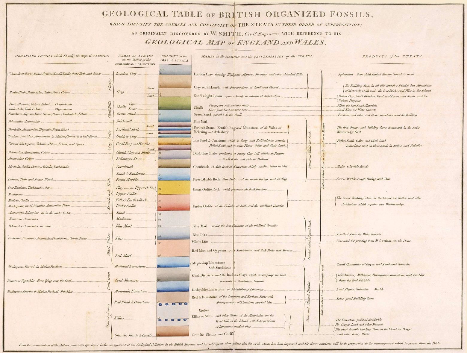

Smith had used one method of ordering the rocks – based on a principle established by Nicolas Steno (1638-1686) defining some of the principles of stratigraphy, specifically the law of superposition which, put simply states that in undisturbed strata the youngest layer is on the top and the oldest layer is on the bottom. Rocks are characterised by their properties and can be put “in order” using evidence where different rocks are in contact, and also by their fossils using the principles of evolution.
In the early days, several geologists were working almost contemporaneously in different areas. Like Smith, they each created a sequence of rocks in their own area. How to correlate between different geologist’s work? Inevitably there was going to be some overlap – how to rationalise these overlaps?
Stratigraphy is the solution – each bed of rock or strata is named and put in age sequence. Rocks from different areas have to befitted in to this growing sequence. Stratigraphy works for rock layers whic hare laid down in sequence such as sedimentary rocks and most volcanic rocks [lavas, ashes, lapilli, pumice etc which are in effect deposited like sedimentary rocks]. Metamorphic and intrusive igneous rocks cannot be fitted into a stratigraphic sequence. However, this general principle assumes rock layers are consistent over a wide area. In practice, many sedimentary rocks are fairly localised – a beach, a river valley or delta, moraines from one glacier. Here some method of estalblsihing age equivalence is needed. Fossils can often help. Sometimes tracing a rock layer across the landscape will reveal how it changes, or what it is equivalent to, somewhere else.
Once a full stratigraphic sequence was established, it became obvious that some form of subdivsion into time zones was needed. Two convenient bases for this could be used, either rocks from a single geological event or environment could be put into a single time zone [eg marine, desert, volcanic episode] or rocks in one geographical area could be put into a zone named after that area.
We are lucky in the UK in that early geological mapping was largely done in the UK and so the main features of the stratigraphic column were established in this country. Early geologists often named their rocks after the area they were studying. So we have the Cambrian – named after Wales, the Ordovician and Silurian – named after Celtic tribes in Wales, the Devonian – named after Devon. The enxt period was named after the main characteristics of its rocks : Carboniferous [carbon, ie coal bearing], subdivided into Limestone, Millstone Grit and Coal Measures from the rocks encounterered across our coalfields in S Wales and the Pennines. The cartoon version illustrated below shows how the international view have superceded the local UK view, with those three subdivsion renamed into Missippian and Pensylvanian.

International Commission on Stratigraphy
The International Commission on Stratigraphy was established to rationalise the national names and to coalesce national sequences in order to create a full time sequence. For example, some areas were land masses at particular times and not collecting a full sequence of sedimentary rocks at that time. Here in teh UK we have a full sequence from the earliest Cambrian to the end of the Ordovician but then became a land masss, in fact a massive mountain chain as the European and American continetal plates collided forming the Caledonian mountains running from the Appalachians, through the UK and up to northern Scandinavia. So our Devonian rocks are limited. The chronostratigraphic chart is calidbrated using radiometric dating – somewhere in the world there will be igneous rocks that can be used for almost every time zone.

https://stratigraphy.org/ICSchart/ChronostratChart2023-06.pdf
Relevance to Anglesey
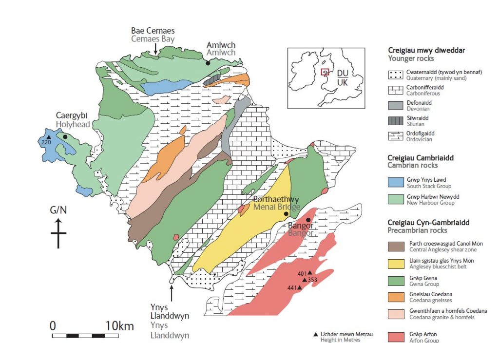
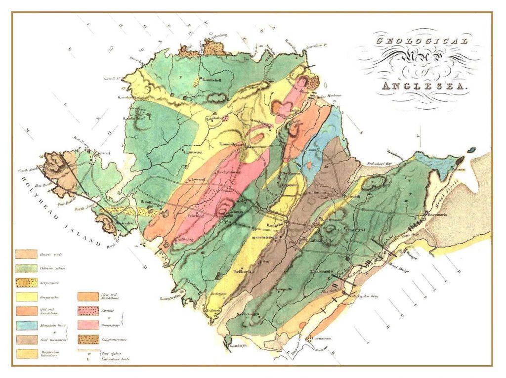
So what does Anglesey’s stratigraphic column look like? Well, Anglesey has been mapped several times, from William Smith ) via R I Murchison in 1843 and A C Ramsay in 1878 to Edward Greenly (1919
Smith identifies the Carboniferous from his nterest in showing coal bearing rocks.

Henslow, Darwin’s tutor at Cambridge, published an outline map of Anglesey which idenitifies the main rock units without ascribing them to time periods.

By 1843 Murchison’s map of the UK does have a lot more detail, his stratigraphic column listing both characteristics of the rocks and the period names

Ramsay’s map published in his book “The physical geology and geography of Great Britain” identifies the carboniferous and notes the (Coedana) granite. It’s hard to tell what the rest is, possibly lower Siluiran? One thing to really note from his straigrahpci column is the absence of the Ordovician.

Greenly retired from the Geological survey having worked extensively in Scotland and took on the task of mapping Anglesey as a ‘hobby’. The result is a two volume memoir running to some 1100 pages and a detailed map. Conventional stratigraphic column on the left and an attempt at the Precambrian and igneous rocks on the right hand side.